Residential For Sale
526 W Mesquite Street, Boise, Idaho 83713

3Bedroom(s)
2Bathroom(s)
19Picture(s)
1,492SqFt
2
Financing available. Newer home nestled in a sought-after neighborhood in Central Boise! This inviting open floor plan is perfect for relaxation and entertaining alike. The kitchen boasts a convenient breakfast bar for casual dining, Samsung refrigerator with a double door slide-out freezer, a new Whirlpool dishwasher, new AC, garbage disposal for added convenience.
$144,900
Residential For Sale
526 W Mesquite Street, Boise, Idaho 83713
3Bedroom(s)
2Bathroom(s)
1,492SqFt
Visits: 2
Financing available. Newer home nestled in a sought-after neighborhood in Central Boise! This inviting open floor plan is perfect for relaxation and entertaining alike. The kitchen boasts a convenient breakfast bar for casual dining, Samsung refrigerator with a double door slide-out freezer, a new Whirlpool dishwasher, new AC, garbage disposal for added convenience.
$144,900
Land For Sale
15 Vernon Ct, McCall, Idaho 83638-1000

25Picture(s)
0.41Acres
1
BUILD YOUR DREAM HOME in Jug Mountain! No need to install well or septic, both are community services and available at the property. Located on a lovely wooded mesa above the golf course and close to the Clubhouse. Enjoy the amenities of Jug Mountain Ranch such as Golf, Hiking, Mountain and Snow Biking, X-country skiing, Snowshoeing, Fishing, and Huckleberry picking. Ponds are stocked.
$179,999
Land For Sale
15 Vernon Ct, McCall, Idaho 83638-1000
0.41Acres
Visits: 1
BUILD YOUR DREAM HOME in Jug Mountain! No need to install well or septic, both are community services and available at the property. Located on a lovely wooded mesa above the golf course and close to the Clubhouse. Enjoy the amenities of Jug Mountain Ranch such as Golf, Hiking, Mountain and Snow Biking, X-country skiing, Snowshoeing, Fishing, and Huckleberry picking. Ponds are stocked.
$179,999
Residential Income For Sale
1416 5th St S, Nampa, Idaho 83651

1Bedroom(s)
1Bathroom(s)
39Picture(s)
856SqFt
2
Well maintained duplex in good location near downtown Nampa. Across the street from Central Elementary. Newer roof (2019). Front unit is a one-bedroom unit with washer/dryer hookups, electric wall unit heaters, and window A/C. This unit has a long-term tenant. Rear unit is a studio with a gas wall furnace. Both units include refrigerators, stoves, and microwave/range hoods.
$275,000
Residential Income For Sale
1416 5th St S, Nampa, Idaho 83651
1Bedroom(s)
1Bathroom(s)
856SqFt
Visits: 2
Well maintained duplex in good location near downtown Nampa. Across the street from Central Elementary. Newer roof (2019). Front unit is a one-bedroom unit with washer/dryer hookups, electric wall unit heaters, and window A/C. This unit has a long-term tenant. Rear unit is a studio with a gas wall furnace. Both units include refrigerators, stoves, and microwave/range hoods.
$275,000
Residential For Sale
910 Moonglo Road, Buhl, Idaho 83316

3Bedroom(s)
2Bathroom(s)
22Picture(s)
1,404SqFt
1
Check out this sunny home. The living space is filled with natural light. It is nestled in a welcoming, tranquil 55+ community. This home has been well maintained, and it shows. The kitchen has lots of storage and space for a large table. Owner just updated some of the windows and had the roof checked and repaired. The attached garage has room for a car, storage and freezers.
$162,500
Residential For Sale
910 Moonglo Road, Buhl, Idaho 83316
3Bedroom(s)
2Bathroom(s)
1,404SqFt
Visits: 1
Check out this sunny home. The living space is filled with natural light. It is nestled in a welcoming, tranquil 55+ community. This home has been well maintained, and it shows. The kitchen has lots of storage and space for a large table. Owner just updated some of the windows and had the roof checked and repaired. The attached garage has room for a car, storage and freezers.
$162,500
Residential For Sale
12153 W Touchrock Lane, Kuna, Idaho 83634

3Bedroom(s)
2.5Bathroom(s)
48Picture(s)
2,320SqFt
2
Stunning single level home located on .61 acre corner homesite backing up to extensive common area. Well manicured mature landscaping, built-in fire ring, wrought iron fencing & oversized covered patio perfect for entertaining. Generous great room w/oversized picture windows w/an abundance of natural light.
$707,800
Residential For Sale
12153 W Touchrock Lane, Kuna, Idaho 83634
3Bedroom(s)
2.5Bathroom(s)
2,320SqFt
Visits: 2
Stunning single level home located on .61 acre corner homesite backing up to extensive common area. Well manicured mature landscaping, built-in fire ring, wrought iron fencing & oversized covered patio perfect for entertaining. Generous great room w/oversized picture windows w/an abundance of natural light.
$707,800
Farm & Ranch For Sale
3536 N 2300 E, Filer, Idaho 83328

3Bedroom(s)
2.5Bathroom(s)
47Picture(s)
82.09Acres
2
Productive 82.09 acre farm featuring approximately 74± Twin Falls Canal Company water shares and 63± acres currently in irrigated crops. The irrigation system is currently set up with hand lines and gravity flow, with strong potential to upgrade to a pivot system for improved irrigation efficiency.
$2,000,000
Farm & Ranch For Sale
3536 N 2300 E, Filer, Idaho 83328
3Bedroom(s)
2.5Bathroom(s)
82.09Acres
Visits: 2
Productive 82.09 acre farm featuring approximately 74± Twin Falls Canal Company water shares and 63± acres currently in irrigated crops. The irrigation system is currently set up with hand lines and gravity flow, with strong potential to upgrade to a pivot system for improved irrigation efficiency.
$2,000,000
Land For Sale
0 Amity Ave, Nampa, Idaho 83687

8Picture(s)
36.45Acres
1
Unlock the potential of this 36.45-acre of agricultural land, poised for redevelopment. Strategically situated near freeways, emerging developments, and thriving shopping centers, this expansive property offers a blank canvas for your vision. Rezoning opens doors to a multitude of possibilities, from residential communities to commercial ventures.
$2,187,000
Land For Sale
0 Amity Ave, Nampa, Idaho 83687
36.45Acres
Visits: 1
Unlock the potential of this 36.45-acre of agricultural land, poised for redevelopment. Strategically situated near freeways, emerging developments, and thriving shopping centers, this expansive property offers a blank canvas for your vision. Rezoning opens doors to a multitude of possibilities, from residential communities to commercial ventures.
$2,187,000
Residential For Sale
8059 W Corinthia St, Eagle, Idaho 83616
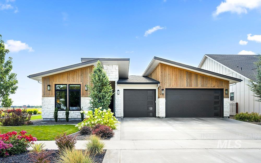
4Bedroom(s)
2Bathroom(s)
27Picture(s)
2,181SqFt
0
An exquisite modern retreat in Eagle’s premier Legacy community, where lush landscaping, shimmering ponds, and resort-style amenities create a lifestyle of luxurious comfort. Designed by Solitude Homes with striking architectural lines & a sophisticated, warm-meets-modern aesthetic, this single-level residence features sunlit open-concept living, tall ceilings, & oak hardwoods.
$799,000
Residential For Sale
8059 W Corinthia St, Eagle, Idaho 83616
4Bedroom(s)
2Bathroom(s)
2,181SqFt
Visits: 0
An exquisite modern retreat in Eagle’s premier Legacy community, where lush landscaping, shimmering ponds, and resort-style amenities create a lifestyle of luxurious comfort. Designed by Solitude Homes with striking architectural lines & a sophisticated, warm-meets-modern aesthetic, this single-level residence features sunlit open-concept living, tall ceilings, & oak hardwoods.
$799,000
Residential For Sale
6954 Saddle Bred Way, Star, Idaho 83669
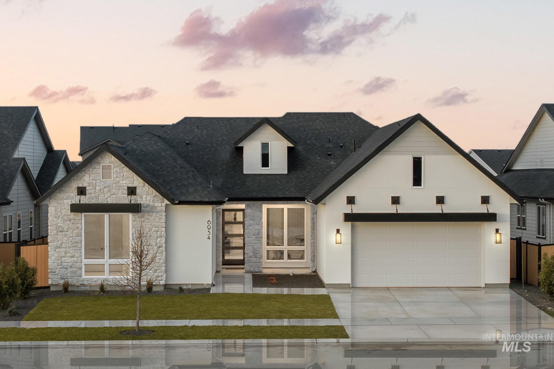
3Bedroom(s)
3.5Bathroom(s)
50Picture(s)
3,000SqFt
0
Don’t miss this stunning Sagewood home in Star’s premier waterfront community! Step inside the long entryway, leading to a spacious great room where vaulted ceilings create a bright and inviting atmosphere. The open layout flows into the dining area and a chef’s kitchen, complete with ample counter space, handsome cabinetry, and a walk-in pantry.
$1,026,028
Residential For Sale
6954 Saddle Bred Way, Star, Idaho 83669
3Bedroom(s)
3.5Bathroom(s)
3,000SqFt
Visits: 0
Don’t miss this stunning Sagewood home in Star’s premier waterfront community! Step inside the long entryway, leading to a spacious great room where vaulted ceilings create a bright and inviting atmosphere. The open layout flows into the dining area and a chef’s kitchen, complete with ample counter space, handsome cabinetry, and a walk-in pantry.
$1,026,028
